Photo credit: Ricardo Makyn for UNDP Multi Country Office in Jamaica
Jamaica’s mining lease process is now digital, boosting efficiencies & environmental safeguards.
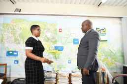
Jamaica’s Commissioner of Mines, Roy Nicholson is resolutely leading his team on a mission to bring the coordination of mining leases into the digital age. He has long nurtured the vision for this transformational leap, which was independently validated by a 2017 study of the Development Minerals Industry.
“I wanted to get rid of all those bundles of paper and paper files … that when anyone asks for a file or asks for information, it is readily at their fingertips,” he explains.
For years, the Mines and Geology Division he leads generated stacks of paperwork for the mine leasing process, then partially kept track by updating a physical map tacked to his office wall.
The map, studded with thumbtacks and colour coded cutouts, identifies mining leases, roads, new applications, Protected Areas to be avoided and other key features. Information lags meant the map was often out of step with the latest developments, sometimes by two or three months.
“If you wanted information from me, I had to turn and look at the map and call someone to help me update the map,” Commissioner of Mines, Roy Nicholson recalls. He says there was also great difficulty in tracking information from key divisions. “The Inspectorate and Geology divisions were speaking two different languages. We weren’t actually on the same page, because the language that the inspectorate uses is almost different from that of the geologist”.
The physical map has now made way for a digital map loaded with information, and accessible anywhere from a digital device.
In mining circles, the digital device is called a Mining Cadastre. The Mining and Geology Division (MGD) brands their cadastre, JAMinCAD.
Because of JAMinCAD, the MGD now has the internal capacity to query and locate: Mineral deposits; licensed quarries; and adjacent assets such as roads, communities, and Protected Areas, mining rights, regulations and licenses. Before the Cadastre was implemented, these tasks required multiple interactions within and beyond the Mines and Geology Division. With the Cadastre, this can be done with a PC or smartphone via secure login access.
“(Now), I can go on my computer and say okay, follow me here and you will actually see all the information that you need.”, Commissioner Nicholson says.
In the next phase, potential investors and licensees will be able to access much of this information as well, ensuring a more transparent and accessible process that permits the public to hold stakeholders accountable to laws and policies.
Deputy Commissioner Stacey Plummer says the Division is now able to view the full picture of mining leases in real time. “We will be able to see it electronically and also in relation to Protected Areas, because everything really has to be balanced when it comes to mining and quarrying so we have to consider the environment as well,” she explains.
“We’re even better able to serve the public because applicants would know where the challenges might be,” she advises. So, we can also help them to adjust the application to see maybe if I should leave all the land that is here because it falls within a protected area for example, instead of getting that information four months down the road,” she says.
Ahead of full rollout that will facilitate mining lease applications from the public via the Cadastre, applicants apply at the mining registry, Plummer further explains. “She says the paperwork is digitally scanned and uploaded along with related documents including responses and approvals from other entities outside the MGD.
During this period, MGD is digitizing different parts of the mine licensing process internally and among all other relevant agencies. Inspector of Mines, Marlon Simms says this includes digitizing inputs from other units including details on soil, rocks, faults, as well as integrating external agencies such as the National Environment and Protected Areas (NEPA) for identification and safeguarding of Protected Areas, and local municipal corporations for the inclusion of development plans.
With all files digitally converted, users will be able to query Quarry/license/mining lease, location, type of material and area of impact by clicking on the digital map, Simms explains.
Public access to the website is expected within six months through a web address accessible through the website of the Ministry of Agriculture, Fisheries and Mining.
As he sees his vision unfolding, Commissioner Nicholson is fully engaged with leading full public roll out. “We want to give each and every one access to information, whether locally or overseas,” he states.
Funding for the Cadastre came from the Development Minerals Programme implemented by the United Nations Development Programme (UNDP) with financing from the European Union (EU). In Jamaica, UNDP implements the Development Minerals Programme in partnership with the Mines and Geology Division of the Ministry of Agriculture, Fisheries and Mining. In the face of persisting environmental, social and economic challenges which has limited the sector’s potential, the Development Minerals Programme has aimed since 2016 to build the profile and improve the management of Development Minerals which includes industrial minerals; construction materials; dimension stones; and semi-precious stones .
This story was originally published by UNDP Jamaica on April 17, 2024
https://undpjamaica.exposure.co/digitally-mapping-a-safer-future-for-mining